Scotland 1865 – Monday Map

June 8 1865, 150 years ago today, John Grant purchased Glenfarclas in Ballindalloch, Scotland

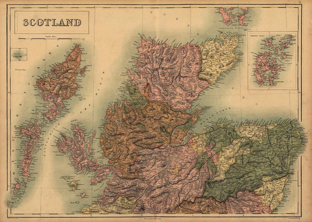
Monday Map celebrates 150 years of excellence and dedication to craft with this rendering of Scotland created that same fateful year.

Scotland 1865 map

Hearty people of a hearty land

Scotland had entered into the United Kingdom 1707 but retained its identity when a young Queen Victoria and Prince Albert fell in love with it on their first visit in 1842.

By 1865 all things Scottish were extremely popular in London and by 1875 Scotch whisky had replaced cognac as the Englishman’s aperitif of choice.

Glenfarclas remains an independent, family owned business, where the 5th and 6th generation continue an unmatched legacy of quality and tradition.


Alan Lomax Music Archive Going On Line

For half a century, musicologist Alan Lomax recorded and preserved priceless cultural treasure.

Thousands of recordings have been digitized for posterity, discovered in the coal country of Kentucky to the cane fields of Haiti, including many legendary voices who would have toiled in obscurity and been forgotten.

With 2015 marking the Alan Lomax centennial, the Association for Cultural Equity is making these recordings available for free.

Read more about that and HERE

Working alongside his folklorist father, John Lomax, the young Alan traveled through the South and West, shining a light on local musicians, allowing the wider world to discover the blues of a prison inmate known as Leadbelly and the ballads of an itinerant laborer named Woody Guthrie.

Those are just two of the voices first recorded by Alan Lomax, out of thousands, and tens of thousands of songs and tunes now preserved for and us and future generations.

The 2002 New York Times Obituary of Alan Lomax is found HERE

Association of Cultural Equity’s website is HERE

The Lomax Family Collection at the American Folklife Center is HERE


Alexander’s Macedonia Legacy – Monday Map

Monday Map – Ancient Macedonia and its principalities, about 100 years after the death of Alexander the Great

ancient macedonia
click to enlarge

In French, but the best map I could find of ancient Macedonia showing Amphipolis, site of the recent revelations at the massive Kasta tomb from the time of Alexander. It is the largest found in Greece.

This homeland of the legendary conqueror Alexander the Great was but a small portion of his empire, which reached all the way to India. This map also shows Rhodes, at the bottom right, from whence came the famous architect Dinocrates, thought to have designed the mega-tomb still being excavated in what is now Northeast Greece.

Also shown is the island of Samos, part of the Greek colonies of Ionia, off the coast of modern day Turkey. It was here that Science was invented by great thinkers like Aristarchus of Samos, who, about about the same time this map represents, offered the earliest known proposition that the planets revolved around the sun and that that the stars were other suns much farther away.

Free from the scrutiny of the authorities far off on the Greek mainland, the scientists of Ionia were free thinkers and developed what we now call the Scientific Method.

Unfortunately, most of their findings and theories were suppressed or disbelieved and the Scientific Method had to wait some centuries more before it was rediscovered, first in Egypt just before the Roman occupation, and then again after the Dark Ages.

For more on the amazing discoveries at the Kasta tomb from ancient Macedonia, please see the following post.


Large Mosaic Uncovered at Amphipolis Tomb

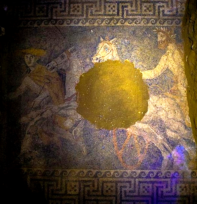
The god Hermes leads the chariot of a bearded man wearing laurels toward the underworld, in a stunning mosaic revealed by the Greek Ministry of Culture, recently discovered at the massive 4th Century BC tomb at Amphipolis in Northeast Greece.

Amphipolis mosaic floor Amfipoli
source: Greek Ministry of Culture

The moasic floor was made with pebbles of six different colors, and were enough found in the chamber that archeologists hope to reconstruct the damaged portions before the tomb is opened to public sometime in the future. Almost 15 x 10 feet in size, the mosaic covers the entire floor of the tomb’s second chamber.

Known as the Kasta tomb (Τύμβος Καστάv,) the site has been under careful excavation since its discovery in 2012. It is the largest tomb ever found in Greece at 1,935ft (590m) in width.

Amphipolis was a major navel port during the reign of Alexander the Great. Three of the tomb’s four known chambers have been entered thus far, and it is assumed to have been built for one of Alexander’s close relatives, and possibly his wife.

Alexander died in Babylon in 323 BC, a month before his 33rd birthday. His tomb is said to be in Egypt, but it has never been found. It is possible the site in Amphipolis is actually a cenotaph, a monument to someone buried elsewhere. The many features revealed by archeologists thus far suggest the work of Alexander’s chief architect Dinocrates of Rhodes.

So, it is possible the site is actually an unoccupied monument to Alexander himself, or his father, Philip II, who conquered the region a generation earlier. Before then Amphipolis had been an independent city state, famous for defeating an Athenian invasion some 80 years before it fell before King Philip.

While a recently discovered hole in an inner wall implies it may have been looted in antiquity, it is still hoped they may know for certain just who it was built for, once they enter the fourth chamber. But the site dwarfs Philip’s own tomb in ancient Aigai some 100 kilometers west of Amphipolis. That is but one reason this site is of so much interest.

Other important discoveries at the site include two large sphinxes and even larger caryatids, and recent photos of both can be seen at various websites.

Related Reading on the Kasta tomb in Amphipolis:

Website dedicated to the tomb at Amphipolis

The Greek Reporter – List of Related Stories

Alias Schmidtt and Jóns

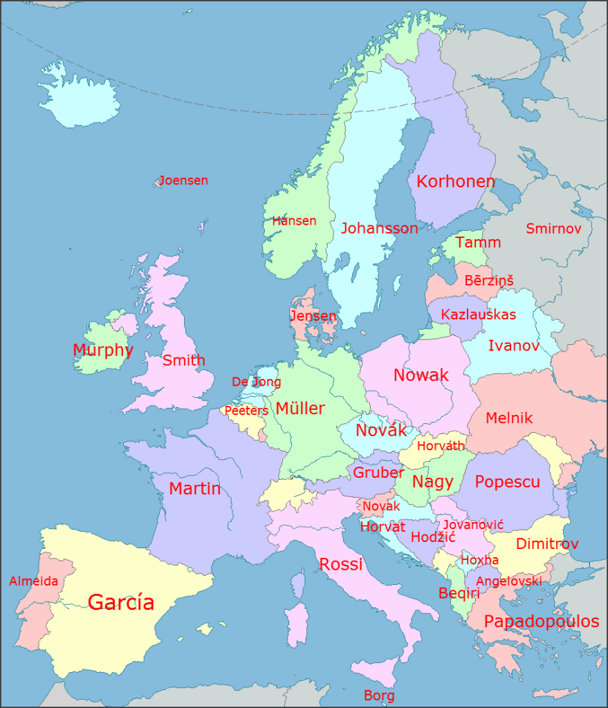
The most common surnames by European nation, are surprising.
Monday Map

Sure if my mother’s maiden name isn’t Murphy

Most Common Surnames

And Unto the Seventh Son of the Seventh Son

This week’s map does not the whole story tell, however. For one thing, I find it fascinating that in Iceland they retain the ancient custom of a last name simply denoting who one’s father is (or mother in some cases.) Where having the English name Johnson once meant you were the son of someone named John, in Iceland a last name of Jónsson literally means your father’s first name is Jón. While everyone with last names starting with O’ or Mc or Mac, or with any number of endings, retain the vestiges of this custom, in Iceland it holds fast as the way things are done.

If your name is Baldur Jónsson, and you are an Icelander, and you name your son Árni, he is not Árni Jónsson, he is Árni Baldursson. If he decides to junior his own name, your grandson isn’t Árni Baldursson, he is Árni Árnasson. His sister Ása is Ása Árnadóttir.

But when it comes to places that do use modern surnames, there are many of them with multiple spellings. As laid down in an interesting forum discussion on Reddit, prompted by the posting of this map, someone suggests that the most common name in Germany would be Schmidt, if one considers all the various spellings such as Schmitt, Schmitz, or Schmid. And that this may have disqualified many other common names with divergent spellings.

In response, someone quipped that the only reason Smith won in Scotland was because McGlauchmluchantire is sometimes spelled McGlauchmluchantyre.

And that reminds me of my dear college chum Diane Muldrow, who has at times been affectionately referred to by more than one of her friends as Diane McMacO’Muldrowskisteina.

As it happens, Diane’s latest book, Everything I Need To Know I Learned From a Little Golden Book reached Number One on the independent bookstore Best Seller List last week.

Way to go Di!

Everything I Need to Know by Diane Muldrow


Earliest human footprints outside of Africa found in England

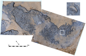
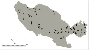
In a thrilling discovery, detailed in a paper published February 7 in the scientific journal PLOS ONE, the earliest human footprints found outside of Africa appeared in May, in ancient sediment along the English coastline at low tide, near Happisburgh, in Norfolk.

The ocean washed them away, but not before they could be studied by scientists and preserved on video, which is scheduled to be shown as part of the new exhibit, Britain: One Million Years of the Human Story. The exhibit opens at the Natural History Museum in London on February 13, and continues through September 28, 2014.

The paper’s abstract is as follows:

Investigations at Happisburgh, UK, have revealed the oldest known hominin footprint surface outside Africa at between ca. 1 million and 0.78 million years ago. The site has long been recognised for the preservation of sediments containing Early Pleistocene fauna and flora, but since 2005 has also yielded humanly made flint artefacts, extending the record of human occupation of northern Europe by at least 350,000 years. The sediments consist of sands, gravels and laminated silts laid down by a large river within the upper reaches of its estuary. In May 2013 extensive areas of the laminated sediments were exposed on the foreshore. On the surface of one of the laminated silt horizons a series of hollows was revealed in an area of ca. 12 m2. The surface was recorded using multi-image photogrammetry which showed that the hollows are distinctly elongated and the majority fall within the range of juvenile to adult hominin foot sizes. In many cases the arch and front/back of the foot can be identified and in one case the impression of toes can be seen. Using foot length to stature ratios, the hominins are estimated to have been between ca. 0.93 and 1.73 m in height, suggestive of a group of mixed ages. The orientation of the prints indicates movement in a southerly direction on mud-flats along the river edge. Early Pleistocene human fossils are extremely rare in Europe, with no evidence from the UK. The only known species in western Europe of a similar age is Homo antecessor, whose fossil remains have been found at Atapuerca, Spain. The foot sizes and estimated stature of the hominins from Happisburgh fall within the range derived from the fossil evidence of Homo antecessor.

(footnotes appear in the actual paper)

Shadows of Forgotten Ancestors

The assumed species of human kind squishing that ancient mud between their toes may have reached Norfolk some 800,000 years ago via a land bridge. At many times in the distant past, Britain was a peninsula directly connected to Europe, and that is believed to be true of the era when these footprints would have been made, possibly by a family searching a riverbed for food. But a cooler climate would have removed such peoples to Southern Europe shortly afterwards. The earliest record of human artifacts in Britain dates from about 500,000 years ago, belonging to Homo heidelbergensis, the species believed to have evolved into the Neanderthals, our distant cousins who thrived in Europe and Britain until shortly after the arrival of our own species, Homo sapiens, some 40,000 years ago. And since our own recorded history, including all our various legends and creation myths only goes back a scant 6,000 years, we are still talking about a verrrrrrry long time ago.

 earliest human footprints outside Africa PLOS ONE  earliest human footprints outsid of Africa PLOS ONE

Dr. Isabelle De Groote of John Moores University in Liverpool concluded they were indeed human footprints, nearly 1 million years old, belonging to multiple individuals who stood between 3 feet to 5 feet 9 inches in height. How many more there were and how permanent was their stay remains a mystery. As the Natural History Museum’s Professor Chris Stringer told BBC News:

“This discovery gives us even more concrete evidence that there were people there. We can now start to look at a group of people and their everyday activities. And if we keep looking, we will find even more evidence of them, hopefully even human fossils. That would be my dream”.

And that is one man’s word on

The earliest human footprints found outside of Africa

Read the paper on PLOS One’s website, HERE

Other Interesting Things

Hubble Telescope discovers ancient galaxies behind Pandora’s Cluster

Monday Map – An American Contemplates the Metric System

Early American Guitars at the Metropolitan Museum of Art

The Impressionists and the Evolution of Modern Fashion

Underground Rail Road Routes – Martin Luther King Day

Monday Map
Underground Rail Road Routes Leading to Canada

I was surprised to find this on a U-Haul truck directly in front of my home in Brooklyn, NY.
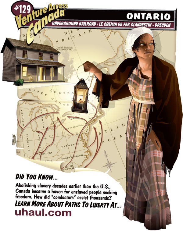
Underground Rail Road Routes - Martin Luther King Day

As most schoolchildren learn, the Underground Railroad was a loose network of people throughout the United States who assisted runaway slaves trying to reach Canada, or other parts of America that refused to recognize the laws saying human slaves were property that must be returned to their owners.

In my little hometown in northwest Ohio, there was a house with a hidden room reputed to have provided sanctuary for fugitive slaves on their way to Ontario. And here in Brooklyn, the church where abolitionist Henry Ward Beecher preached had a secret tunnel that led to the East River, for the same purpose.

During the colonial period, Brooklyn contained a plantation with more slaves than anywhere else in the north. Across the East River, New York of the 1820s had more slaves than any city other than Charleston, South Carolina, and the area in Kings County around Brooklyn likewise had many people still enslaved. It is hard to imagine how anyone in a civilized nation could be capable of such monstrous barbarity. And yet, it was not all that long ago.

So, this seemed a most appropriate map for today, the Martin Luther King federal holiday, in this particular year of 2014, the 50th anniversary of the Civil Rights Act of 1964.

Half a century ago today, African-Americans were not yet afforded full protection of equal rights as citizens of the United States in many places in the country. And large populations of whites, including government officials, staunchly opposed the very idea, some going even as far as committing terrorist acts, including murder, to derail the freedom train that once road the routes of the Underground Railroad.

And 100 years before that, the nation was deep into a bloody civil war ignited primarily because of slavery, and the issue of whether or not individual states had the right to continue that institution regardless of possible prohibition under federal law. The outcome of that war was far from certain when, on January 19, 1864, General Grant, then leading the Division of the Mississippi, wrote to General George Henry Thomas to explain there was a shortage of troops, as many were sent home on furloughs to see their families, as reward for reenlisting. Once the winter ended they would begin the invasion of the Deep South, and the battles with the most horrendous loss of life lay ahead.

President Lincoln was up for re-election in the fall, with considerable opposition to his policies. And the Senate was on the verge of debating the passage of Thirteenth Amendment to the United States Constitution, abolishing slavery and involuntary servitude, except as punishment for a crime. It would pass on April 8. But the House of Representatives would not pass it until December of 1865, nine months after the President’s assassination.

One hundred and fifty years later, in 1964, descendants of all those freed slaves were still suffering under the apartheid system known in America as Segregation. Even after the Civil Rights Act became law, there were many struggles ahead. Dr. King, the courageous and charismatic leader among civil rights activists was still on the front lines of that cause four years later, when he met his own death from an assassin’s bullet.

The U-Haul truck in question apparently originated in Ontario. But it had been rented in Brooklyn by the new lodger moving in to share my apartment. By no means fleeing slavery, she was escaping from a different sort of domestic hell, at less cost than professional movers.

It helps illustrate just how much effort one will put into labor when they are working for themselves, rather than working to make some rich guy even richer.

Bravo for U-Haul. You can find more interesting regional and commemorative artwork at

http://www.uhaul.com/SuperGraphics/