America / History / Just the facts / Opinion
American Cancer
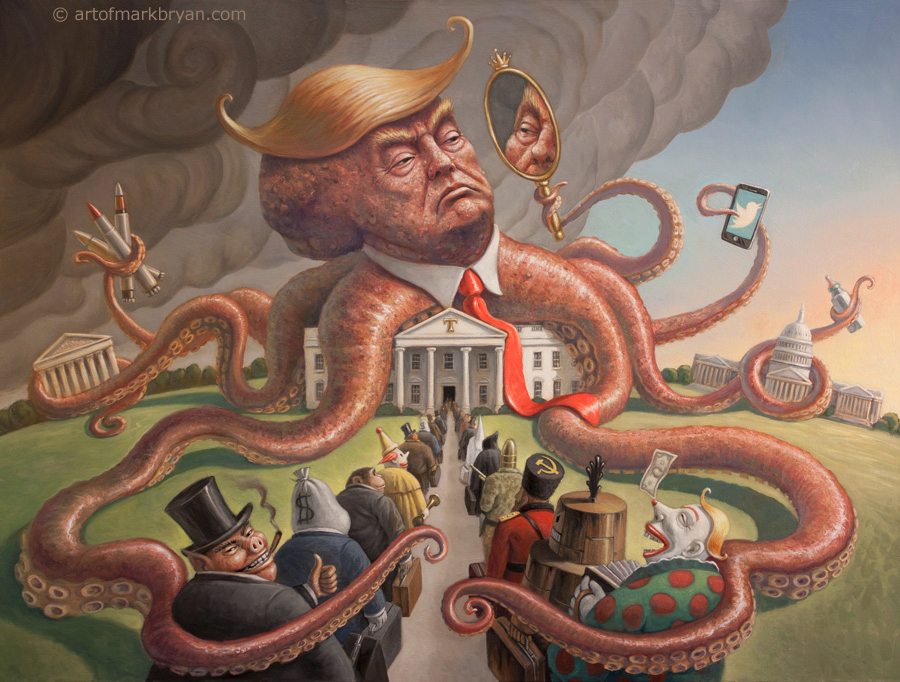
“Never underestimate the power of stupid people in large groups”
The wealthy minority who will never need social security or health insurance ride unbridled into power, on the easily fooled dupes whose religious extremism is on par with the Taliban, and on the blood, sweat, prejudice, and blind ignorance of millions of common Americans who have voted the bread out of their own mouths, and the healthcare out of their own lives and the lives of their children and grandchildren. And all for a proven sociopathic con artist with not a pinprick of empathy in his veins, because they’re convinced that he’ll protect them from the imaginary enemies they fear, and the scapegoats they know little about, other than what they’ve been told to stoke their paranoid fantasies.
As early as the 1980s, prophets of doom warned us about the forces promoting anti-intellectualism, who were truly polluting the lifeblood of the nation by dumbing down the population. I am glad that great Americans like Dr. Carl Sagan did not live to see these worst and perhaps final days of the republic for which they once stood – yes, even worse than when the wealthy minority who prospered on the abomination of slavery almost destroyed the first and best hope for democracy in the modern world. They never made it to the White House.
Four score years later, half a million Americans died fighting fascism in the 1940s. Now, another four score years after that, Americans spit on their graves as they elect the first openly fascist party in US history, sweeping all three, well, eventually all four branches of government.
Comrade Putin and the Ku Klux Klan applaud these election results. I despair for all their innocent victims who are going to be devastated and destroyed by America’s heartless stupidity.
As a white male of advanced years and Anglo-Saxon genes now living in a cosmopolitan city on an island off the coast of America, this grotesque ethical collapse of my nation of birth will have little direct impact upon me, other than what might happen to Medicare in the relatively few years I have left. But it grieves me worse than the death of loved ones.
I grieve as much for the woman in Texas who died from a miscarriage last week because medical personnel in an ER defied their Hippocratic Oath rather than face prison time for saving her life. If you voted for Trump in 2016, you murdered that woman.
Ignorance of who Trump really is might have been used as an excuse back then. But not now.
The deaths of Americans, Ukrainians and others that are directly attributable to Donald Trumps’ first term, as well as his corruption of the United States Supreme Court, were enough to damn him in the eyes of all decent, ethical people. And yet here we are again.
Those of you who voted for this criminal, the most dishonest and dishonorable man to ever defile and desecrate the Oval Office, and the bigotry, hypocrisy, and pitiless greed he represents, can expect nothing from me but scorn. I consider each of you to be a malignant cancer cell and the only true enemy within the United States.
I will buy lottery tickets now and again, just for the hope of emigrating to the civilized world to get as far away from you as possible.
Until then, mort au fascisme! Vive la resistance!!
~
“One of the saddest lessons of history is this: If we’ve been bamboozled long enough, we tend to reject any evidence of the bamboozle. We’re no longer interested in finding out the truth. The bamboozle has captured us. It’s simply too painful to acknowledge, even to ourselves, that we’ve been taken. Once you give a charlatan power over you, you almost never get it back.”
– Dr. Carl Sagan, The Demon Haunted World: Science as a Candle in the Dark
“When fascism comes to America it will be wrapped in the American flag and carrying a cross.
– Anonymous American prophet