American Rivers – Monday Map

Can you find your hometown river on this map of  Untied States, made up entirely by American rivers?

American rivers map Blanchard s
click to enlarge

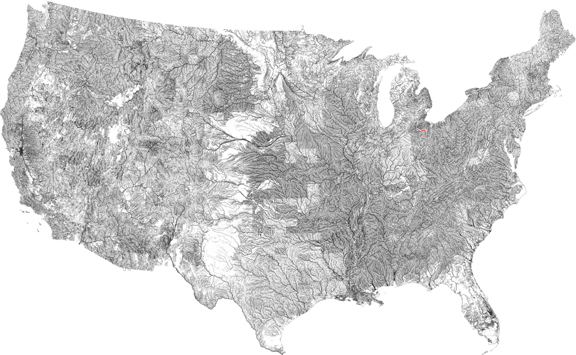
I was able to identify the Continental Divide easily enough. That is where rivers change from flowing toward the Atlantic and Caribbean to rivers that empty into the Pacific. And some of the major waterways are immediately recognizable, as are some state borders created by American rivers. But it is amazing to see just how many individual rivers there are in this one nation on the planet Earth.

It took some scouring of satellite maps, but I was able to find mine own hometown river – the Blanchard, in northwest Ohio. It is highlighted in red, although you may need to click on the map to enlarge it enough to make that out.

Queghtuwa was one aboriginal name for this tributary of the Auglaize, which feeds the Maumee on its way from Ft. Wayne, Indiana to Toledo, Ohio, where it empties into Lake Erie. I must confess, until I saw this map of the continental U.S. made up entirely of rivers, I had no idea exactly where the Blanchard started and where it ended. I just watched it roll by throughout my formative years, when I wasn’t swimming in it.

Rivers are taken for granted these days, but they have been at the heart of human civilization since prehistoric times. Where there’s water there is life. And where there is a river, there was fish, game, irrigation, and arteries to transport goods and people with relative ease for millennia before airliners and motorways, railroads and stage coaches, or even oxcarts and chariots.

Their earlier importance remains with us today, in all the territorial boundaries that include rivers, as well as all the many names of places and things named after rivers, from the Rhineland, to Thames Television, to the Ebola virus.

Where I come from, Blanchard Valley was used as a title for everything from recreational areas to the hospital where I was born. But one would be hard pressed to find any sign of a valley there. After a glacier sat its keister on the area for several centuries, the highest peak in the county is the man made reservoir. But meandering there through the pancake flat landscape was the most interesting geographic feature, the lazy, brown Blanchard River.

Named after a Frenchman who settled among the Shawnee Indians sometime after the American Revolution, the Blanchard once fed the Black Swamp, which was drained long ago and tamed into fertile flat fields of corn, soy beans, and sugar beets.

In recent years the Blanchard River made the front page of the New York Times, where a photo of my cousin appeared. He was in a small boat traversing his neighborhood, which had been flooded by the Blanchard. His home was flooded twice in three years, when the Blanchard was known for flooding once every thirty-five years. It is suspected that development of outlying areas has filled in or altered the natural watershed of streams and creeks, resulting in undue pressure put upon rivers like the Blanchard.

And at a cost of over $100 million in Findlay, Ohio alone, in just one flood, it is clear that muddy rivers rise up to smite us, when we take them too much for granted.

A massive version of this map can be found at http://bost.ocks.org/mike/us-rivers.png

Ghost Map of London – Monday Map

With the media Ebola circus reaching hysterical levels, the World Health Organization announces that the outbreak has ended in Nigeria. And this week’s Map is one of the most important made in the modern world. Known as the Ghost Map, it shows a section of Soho, in London in the year 1854, and it was drawn by the physician John Snow.

Ghost Map of London by John Snow

It was given its spooky title because it indicates the number of deaths at each residence during a particularly virulent outbreak of cholera, the horrific disease that causes violent expulsion of fluids from both ends of the victim, until they die. Although not always fatal, it was a fearful scourge in nineteenth-century Europe, and it still kills thousands of people annually around globe in our own time. It is spread through human waste infecting drinking water. Snow was the first to discover this.

In 1854, the world medical community believed diseases like cholera and typhus were caused by bad air, or “miasma.” Dr. Snow had treated cholera victims in a mining community before moving to London, and wondered why he could breathe the same air as they but did not contract the disease. He risked his life to plunge into the neighborhood suffering the most fatalities during the London outbreak, where he conducted a door to door census of cholera victims.

Snow discovered that the area with the most victims were near a particular public water pump on Broad Street. He further discovered that victims who did not live there either worked at a nearby factory, or had water fetched from the pump because they thought it tasted better than their local pump. Meanwhile, the local brewery had no victims amongst the employees, because they were given a daily ration of ale and according to the owner none of them drank water at all.

Cholera Ghost Map Closeup
He alerted authorities who removed the pump handle and had local water supplies treated with chlorine, which led to the end of the outbreak. It was learned much later that an old cesspit had been paved over and forgotten about was the source of the contamination.

Although this was not the first time someone made a map showing the distribution of cholera victims during an outbreak, it was the first time that cholera outbreaks were linked to drinking water. As a result, Dr. John Snow is credited as the father of modern Epidemiology, which the World Health Organization “defines as the study of the distribution and determinants of health-related states or events (including disease), and the application of this study to the control of diseases and other health problems.”

Snow had already established his reputation as a champion of early anesthetics, having perfected devices for administering chloroform and ether. In 1853, he successfully used chloroform on Queen Victoria during the birth of her eighth child, which increased public acceptance of anesthesia. He also performed the same procedure four years later, for the birth of her ninth child.

Dr. John Snow died of a stroke four years after creating his Ghost Map. Unfortunately, his assertions about the distribution of cholera through drinking water were rejected by most of the medical minds of the time. In the 1870s the established medical community officially declared miasmata as the source of cholera infection. An Italian doctor had first seen cholera bacteria through a microscope the same year Snow made his map. It was rediscovered and isolated by a German scientist in 1884, but even then people failed to recognize that it was spread through drinking water, clinging to the bad air model. And as late as the major typhus outbreak in Germany in 1901, authorities refused to abandon such mistaken ideas.

It remains difficult to get populations to understand the importance of clean drinking water. In fact, Cholera is more common worldwide today than any time since World War II, as can be seen in this bonus map.

cholera spread map

It is sad statement on the disparity of wealth and health in the twenty-first century. At least the disease is treatable and reduced to a rarity in the industrialized “first world.”

Dr. John Snow is remembered today by chapters of the John Snow Society, and there is even a pub in London that bears his name, and has his portrait on the sign. The bartenders claim to have the actual handle removed from the Broad Street pump by John Snow in 1854.

John Snow and his Ghost Map figures prominently in a new series on PBS called How We Got to Now, in the episode entitled Clean, which describes “how our battle against dirt created the sidewalk, the swimming pool, the flat screen and the iPhone” – not to mention modern skateboarding. This excellent six-part series is hosted by the popular American science author Steven Johnson, and explores how ideas arise and develop, often with unintended and far-reaching consequences. It is sort of a combination of earlier science series like Carl Sagan’s Cosmos and James Burke’s Connections. I recommend it highly.

Ghost Map Related Reading:

On the Mode of Communication of Cholera, Excerpts from John Snow’s own 1855 publication, at the website of the University of California at Irvine.

John Snow Society – official website

A Visit to the John Snow Pub – a blogger’s tail

World Health Organization – the official website

How We Got To Now – the PBS Series

Reheat Pasta to Lower Blood Glucose – Trust Me, I’m a Doctor

The BBC News Magazine writes that an experiment conducted by the television program Trust Me, I’m a Doctor suggests reheating pasta can greatly reduce the rise in blood glucose.

University of Surrey scientist Dr. Denise Robertson explained  how cooked pasta that had been cooled down would be treated similar to fiber, resulting in fewer calories absorbed, a smaller peak in blood glucose, while providing greater nourishment for helpful gut bacteria.

It was not known what happens when you reheat pasta.

But it was suspected that reheating the pasta would negate such healthful benefits. So Dr Chris van Tulleken of Trust Me, I’m a Doctor decided to find out. He was surprised to learn the opposite appears true.

Cooling cooked pasta and then reheating it seems to convert the pasta to an even more “resistant starch” that digests more slowly, and in their one experiment with several volunteers, blood glucose levels were notably lower than eating cooled pasta, and 50% lower than eating pasta that had never been cooled.

As a result of the experiment, Diabetes UK will fund further research by Dr. Robertson into whether resistant starch like reheated pasta could improve blood test results associated with Diabetes.

Trust Me, I’m a Doctor tests common health claims and concerns about things like probiotics, vitamin C, plastic water bottles, and emergency first aid treatments.

Read the Full BBC Article Here

Official Trust Me, I’m a Doctor webpage

While one experiment hardly proves the case, I will now start cooling my pasta during my rare carb indulgences and try reheating it in a steamer.

Beefaroni brithday treat onemanz.com pasta


Alexander’s Macedonia Legacy – Monday Map

Monday Map – Ancient Macedonia and its principalities, about 100 years after the death of Alexander the Great

ancient macedonia
click to enlarge

In French, but the best map I could find of ancient Macedonia showing Amphipolis, site of the recent revelations at the massive Kasta tomb from the time of Alexander. It is the largest found in Greece.

This homeland of the legendary conqueror Alexander the Great was but a small portion of his empire, which reached all the way to India. This map also shows Rhodes, at the bottom right, from whence came the famous architect Dinocrates, thought to have designed the mega-tomb still being excavated in what is now Northeast Greece.

Also shown is the island of Samos, part of the Greek colonies of Ionia, off the coast of modern day Turkey. It was here that Science was invented by great thinkers like Aristarchus of Samos, who, about about the same time this map represents, offered the earliest known proposition that the planets revolved around the sun and that that the stars were other suns much farther away.

Free from the scrutiny of the authorities far off on the Greek mainland, the scientists of Ionia were free thinkers and developed what we now call the Scientific Method.

Unfortunately, most of their findings and theories were suppressed or disbelieved and the Scientific Method had to wait some centuries more before it was rediscovered, first in Egypt just before the Roman occupation, and then again after the Dark Ages.

For more on the amazing discoveries at the Kasta tomb from ancient Macedonia, please see the following post.


Large Mosaic Uncovered at Amphipolis Tomb

The god Hermes leads the chariot of a bearded man wearing laurels toward the underworld, in a stunning mosaic revealed by the Greek Ministry of Culture, recently discovered at the massive 4th Century BC tomb at Amphipolis in Northeast Greece.

Amphipolis mosaic floor Amfipoli
source: Greek Ministry of Culture

The moasic floor was made with pebbles of six different colors, and were enough found in the chamber that archeologists hope to reconstruct the damaged portions before the tomb is opened to public sometime in the future. Almost 15 x 10 feet in size, the mosaic covers the entire floor of the tomb’s second chamber.

Known as the Kasta tomb (Τύμβος Καστάv,) the site has been under careful excavation since its discovery in 2012. It is the largest tomb ever found in Greece at 1,935ft (590m) in width.

Amphipolis was a major navel port during the reign of Alexander the Great. Three of the tomb’s four known chambers have been entered thus far, and it is assumed to have been built for one of Alexander’s close relatives, and possibly his wife.

Alexander died in Babylon in 323 BC, a month before his 33rd birthday. His tomb is said to be in Egypt, but it has never been found. It is possible the site in Amphipolis is actually a cenotaph, a monument to someone buried elsewhere. The many features revealed by archeologists thus far suggest the work of Alexander’s chief architect Dinocrates of Rhodes.

So, it is possible the site is actually an unoccupied monument to Alexander himself, or his father, Philip II, who conquered the region a generation earlier. Before then Amphipolis had been an independent city state, famous for defeating an Athenian invasion some 80 years before it fell before King Philip.

While a recently discovered hole in an inner wall implies it may have been looted in antiquity, it is still hoped they may know for certain just who it was built for, once they enter the fourth chamber. But the site dwarfs Philip’s own tomb in ancient Aigai some 100 kilometers west of Amphipolis. That is but one reason this site is of so much interest.

Other important discoveries at the site include two large sphinxes and even larger caryatids, and recent photos of both can be seen at various websites.

Related Reading on the Kasta tomb in Amphipolis:

Website dedicated to the tomb at Amphipolis

The Greek Reporter – List of Related Stories

Backpacker finds three-inch leech up her nose

Around the web – a 24-year-old Scottish woman returned from a trip to Southeast Asia suffering nosebleeds, which she assumed were related to an accident.

As Daniela Liverani told a Scottish newspaper, “Two weeks before I came home from Asia, I started having nosebleeds but I’d fallen off a motorbike so thought I’d burst a blood vessel.

“After I got home, the nosebleeds stopped and I started seeing something sticking out of my nostril. I just thought it was congealed blood from the nosebleeds.

“I tried to blow him out and grab him but I couldn’t get a grip of him before he retreated back up my nose.

“When I was in the shower, he would come right out as far as my bottom lip and I could see him sticking out the bottom of my nose.

“So when that happened, I jumped out of the shower to look really closely in the mirror and I saw ridges on him. That’s when I realised he was an animal.”

hree inch leech up noseMs. Liverani, praised the calmness and concern of the doctors at the Edinburgh hospital who took a painful 30 minutes to remove the parasite, which she dubbed “Mr. Curly” before boiling the creature and throwing it away.

One leech expert suggested the parasite could have entered the woman’s nose while she was swimming, or simply by having a drink of water. Hard to imagine not feeling something so large entering the nose or mouth, but I guess leeches have had a lot of practice at such stealthy maneuvers.

Suddenly my life as a Brooklyn mosquito magnet doesn’t seem all that bad.

Reading related to the Backpacker finds three-inch leech up her nose

Sunday Mailweb version with photos of original newspaper story

Daily Telegraph10 Horrible critters that will ruin your holiday

European Nations by Any Other Name – Monday Map

Monday Map showing how the name of European nations, when translated literally from Chinese, according to Haohao Report, can be rather amusing.

Map of Europe translated from Chinese
click to enlarge

What’s In A Name?

Some leeway has been taken here, since certain Chinese characters can have more than one meaning, depending upon usage and dialect. Also, when naming countries for maps, the Chinese would often choose characters that sounded close to the syllables used to pronounce the official name of the country in question. For example the official name of Spain is España, which in Chinese became Xi Ban Ya, or “West Class Tooth.”

This brought to mind a question I have posed for many years, why don’t we call Germany Deutschland and a German Deutsch?

A German by any other name would be as Deutsch

I know why we call Germany Germany; it comes from the Latin germanicus, which was used to describe the tribes in that part of the world during the Roman Empire.

That is not a very satisfying answer, considering we have had a thousand years to figure out what a place is actually called. It has been 200 years since Deutsch was offered to the world as the official term of national identification. But we keep right on with this German nonsense.

Sometime around Nixon’s visit to China we were suddenly asked to start calling Peking by its more accurate pronunciation of Beijing. In less than 20 years it became second nature to use the correct name. Why can’t we do the same with Deutschland? After all, we call Finland Finland.

But then, its name isn’t Finland, is it? It is Suomi.

It just seems arrogant to me, or at least rather lazy in this information age to expect a Svenska person from Sverige to come to America and continually say “I am Swedish from Sweden.”

I understand that certain languages make it rather difficult to master the actual name of well-known countries. But many of the names we use are no less absurd than those on the map above. However, if we followed the Peking to Beijing model, with schoolchildren taught the proper names at an early age, reenforced by the New York Times and other sources of record, it probably wouldn’t take all that long to adjust to calling our friends and neighbors on the planet by their actual names, instead of “You from that place I don’t know how to pronounce.”

Here are the names of European lands, according to themselves. Some use symbols and characters we do not. Sometimes their spelling actually sounds like ours. But in many cases we come nowhere near the mark.

English Name   –   Local Name (different alphabet) [pronunciation]

Albania   –   Shqipëria [Ship-per-EE-ya ]

Andorra   –   Andorra

Austria   –   Österreich

Azerbaijan   –   Azərbaycan

Belarus   –   Biełaruś

Belgium   –   België

Bosnia and Herzegovina   –   Bosna i Hercegovina

Bulgaria   –   Bŭlgarija

Croatia   –   Hrvatska

Czech Republic   –   Česko

Denmark   –   Danmark

England   –   England

Estonia   –   Eesti

Finland   –   Suomi

France   –   France

Germany   –   Deutschland

Greece   –   (Elláda)

Hungary   –   Magyarország

Iceland   –   Ísland

Ireland   –   Éire

Italy   –   Italia

Latvia   –   Latvija

Liechtenstein   –   Liechtenstein

Lithuania   –   Lietuva

Luxemburg   –   Luxembourg

Macedonia   –   (Makedonija)

Moldova   –   (Moldova)

Monaco   –   Monaco

Montenegro   –   (Crna Gora)

Netherlands   –   Nederland

Norway   –   Norge

Poland   –   Polska

Portugal   –   Portugal

Romania   –   România

Russia   –   (Rossiya)

San Marino   –   San Marino

Serbia   –   (Srbija)

Scotland   –   Scotland – the Scots name, Alba is the Gaelic term

Slovakia   –   Slovensko

Slovenia   –   Slovenija

Spain   –   España

Sweden   –   Sverige

Switzerland   –   Helvetica – official name that avoids favoring one language over others.

Turkey   –   Türkiye

Ukraine   –   (Ukrajina)

 Wales   –  Cymru [KEM reh]