Woodstock Festival 1969 – Monday Map

Woodstock’s Three Day’s of Peace and Music

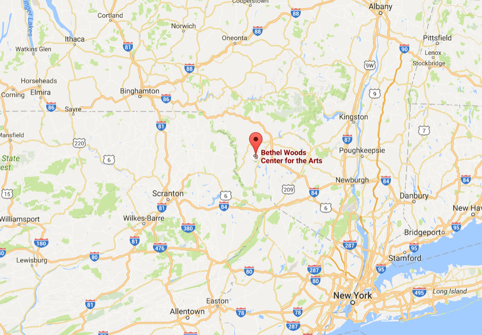
Actually it took place some 50 miles from Woodstock, NY, near the town of Bethel. The site is currently occupied by the Bethel Woods Center for the Arts.

1969 woodstock festival location


My own Woodstock memory comes ten years after the fact.

I was a freshly minted young adult when I attended the midnight movies on Hollywood Boulevard, in Los Angeles, California, to see the film Woodstock, some weeks before the official 10th anniversary was about to take place.

As I waited in line I was befriended by an older guy, with long hippiefied hair and a mustache partially hiding the fact he was missing his two upper front teeth. He claimed he had lost them at Woodstock and that he has a brief cameo in the documentary. He also provided me with various hippiefied things we could ingest to increase the mood of the event.

We sat in the front row of what was my first of many viewings of this iconic film. And indeed, he appeared on the screen, 10 years younger but recognizable.

That next day I was off to the Hollywood Bowl to see a very special concert. I had won tickets on the radio, when I had called up to request a song. Knowing no one in LA that could go, I went alone – without sleep, since I was still soaring from the stimulating night before.

The concert was the first major event that would lead to the “No Nukes” concerts that took place around the U.S. in the coming months.

Being August in LA, I stopped at the Safeway where Hollywood and Sunset meet, to get some fresh fruit and as much water as I could carry, and took the bus to the concert.

As a ticket winner I was allowed in early, and was amazed to see my current hero, David Lindley in person, on stage, doing a sound check with Jackson Browne. I rushed down the sundrenched aisle and accidentally bumped into a woman who had suddenly risen from a chair and started heading up the aisle. I stopped and grabbed her by the shoulders to steady her and to apologize, to Joan Baez.

There she was, looking into my wide eyes with the dilated pupils, the same woman I had seen 12 hours earlier, very pregnant and ten years younger, sending out an a cappella “Sweet Home Sweet Chariot” thundering over the midnight hills and midnight movie like a Valkyrie priestess. And thus the most profound and seriously enjoyable time trip ensued.

Graham Nash and John Sebastian also appeared, also ten years older than I had seen them a few hours before. I sank into my box seat and soaked up the heat and fruit and water, never sure if the quivering waves before my eyes were from the heat or hippified ingestiments.

This was primarily small and acoustic performances. There were no big speakers or large bands. The closest being Maria Manchester, who was joined by her father and brother and others, playing the oboe and cello as I recall.

Peter, Paul, and Mary were the real headliners, but the single most impressive performance came from John Denver, of all people, who took advantage of the acoustics to step out in front of the microphones and simply blow everyone away with his own a cappella vocal prowess.

Ten years on, the spirit the pervaded the Woodstock was still very much alive and well in 1979, despite the fact the radio and Hollywood and Sunset were full of disco queens of both sexes by this time. And my identity remained rooted very much in the social-political idealism of Woodstock and the No Nukes movement pretty much to this very day.

Peace

The Deadly Zone Rouge of France – Monday Map

Some 100 square kilometers of France are closed to people and known as Zone Rouge – the Red Zone.

The land there is poisoned by the human folly that was World War I. A century later it remains perilous to tread upon.

Zone Rouge - France's Deadly Red Zone

Most people are unaware this caged landscape exists among the otherwise beautiful French countryside, near the border with Belgium, as it is surrounded by countryside that has been slowly and imperfectly reclaimed.

There the Red Baron fought and fell, along with countless others of less-lofty reputations.

There the Red Baron fought and fell, along with countless others of less-lofty reputations. And there also are found the city of Verdun and the River Somme – names synonymous with human suffering on an obscene scale, because of the atrocious loss of life that took place there.

As revealed in eye-opening detail at a Messy Nessey, a blog dedicated to all sort of curiosities, Zone Rouge is downright macabre and other-wordily, yet cautiously explored by nearby residents who continue to harvest a ghastly collection of munitions and human remains.

“… the forsaken territory, originally covering more than 1,200 square kilometres (460 sq miles) in the years following the Great War. Today, around 100km2 (roughly the size of Paris), is still strictly prohibited by law from public entry and agricultural use because of an impossible amount of human remains and unexploded chemical munitions yet to be recovered from the battlefields of both world wars…”

The essay is supplemented with many photos from one Olivier Saint Hilaire, which are indeed evocative. With more found via the link to his personal website.

This representational map of the Somme campaign makes up the Red Zone area between the towns of Cambrai, Arras, and Amiens.

The Somme 1916

The Lost Generation

One hundred years ago, one of the most cataclysmic battles in human history was raging in northern France.

The Battle of the Somme began on July 1, 1916. Fifty-three years earlier, on July 1, 1863, the battle of Gettysburg commenced in Pennsylvania.

Over three days of fighting at Gettysburg, a total of 51,112 Americans on both sides were lost as casualties during the entire battle, with some 7,000 killed outright. It remains the bloodiest, most lethal three days in American history.

During the first day’s fighting at the River Somme, the British Army alone lost over 57,000 men, with 20,000 dying on the field.

Fifty-seven THOUSAND.

The battle lasted four months. The combined losses of the Franco-British and Imperial German armies were over 1.5 million men.

One and a half MILLION men.

On Thursday last, millions watched the semifinal football match of the European championships, between France and Germany. These young men, almost all of them in their 20s and among the finest physical specimens their nations could produce, were giving everything they could to prove victorious for the expectant countries and their own personal glory. And throughout the relatively civil competition, I was haunted by the fact that these same champion athletes would almost certainly have been wearing the uniform of opposing armies locked in deadly strife, had they been born 100 years earlier.

They would have undergone a very different kind of training and physical conditioning to hone their elite skills for the purpose of killing their fellow Europeans, in a war between states whose rulers were, in some cases, cousins.

cousins

The tragic absurdity of the so-called Great War isn’t found in the fact closely-related cousins could inflict such horrors upon their own closely-related European peoples. But rather, that the people of Europe could have done it all over again less than 30 years later – with far greater loss of treasure and human lives.

As the United Kingdom prepares to leave the European Union, it is important to remember that the peace that has existed there is not to be taken for granted. Rather, it has required an enormous change of attitudes in nationalism, jingoism, and xenophobia, and continual efforts since the end the Second World War to prevent backsliding.

May the centennial of the Somme and other atrocious acts of war in the coming months and years help to educate and to supplicate the current tensions rippling across Europe and its neighbors.


The Most Significant 4th of July – Monday Map

The 4th of July is set aside to commemorate the signing of the Declaration of Independence, which actually took place on July 2, 1776.

But the most important July 4th of all was that of 1863, when it was celebrated as a national day thanksgiving and of mourning, at least throughout the northern states.

On that date, the city of Vicksburg, Mississippi surrendered to the combined forces under the command of General Ulysses S. Grant, at the end of a long, grueling siege during the War of the Rebellion, now typically referred to as the America Civil War.

Vicksburg 4th of July map

Vicksburg map 4th of July

And on that same 4th of the July the rebel forces of General Robert E. Lee withdrew in defeat from the fields of Gettysburg, Pennsylvania, from where they retreated south across the Mason Dixon Line, and never again posed any serious threat to the nation’s capital, nor to any northern state.

gettysburg-map 4th of July 1863

While the timing in Pennsylvania was accidental, at Vicksburg it was anything but.

The commander of the Confederate forces within the beleaguered city was born and raised a Northerner. He chose to surrender on the 4th of July, saying he knew his northern people and that they would give better terms on that day than on any other day of the year.

The very first 4th of July may have rang the knell for the birth of our nation. But it was this later, more important 4th of July which helped forge in the crucible of the Civil War a single nation from a more imperfect collection of discordant states.

And even if some continue to kick and scream from what Mr. Lincoln called a new birth of freedom.


Summer Days – Monday Map

Average Maximum Temperatures for July 2015

On the lovely first day of Summer, 2016, here is a look at what may be in store for us this coming July.

Summer Days - July 2015 temperatures
Spring as come and Spring as gone, but Summer beckons.

I grew up assuming that August was the hottest month, and it was supported by first hand experiences in recent years, as I am usually found outdoors at Martinfest in Nazareth, PA in August.

But that is the first weekend of the month and apparently more like July than the rest of August. In fact, July is almost always the hottest month of the year in the USA.

And now, if you will excuse me, I am heading out into the beautiful day, while June lasts.

Duluth, Minnesota 1891 – Monday Map

50 years before Bob Dylan was born there

On May 24, 1941 – 75 years ago

Monday Map Duluth 1891

Although he denied his actual origins and place of birth at first, in an effort to create some mystery and an image associated with intrepid figures like Woody Guthrie and Billy the Kid, Bob Dylan was born in Duluth, the Great Lakes port, before his family moved to the North Country mining town of Hibbing, MN when he was 6 years old.

Hibbing, Minnesota in the 1940s

Hibbing Minnesota north of Duluth 1940s

Hibbing Minnesota train to Duluth 1940s Bob Dylan

His mother grew up there, and his father worked for the family electrical supply shop. The young Bob Zimmerman had a normal merchant-class upbringing, and like many teenagers he wanted to play the electric guitar in a rock and roll band.

And that is something he did to revolutionary effect, when he first toured with an electric guitar, in 1966, 50 years ago.

In fact, his double album Blonde on Blonde was released on May 15, 1966, and he performed the infamous “Judas” concert in Manchester, England on May 17.


Manhattan 1776 – Monday Map

Website Shows New York City Boundaries Over 250 Years

Manhattan Island Slowly Swallowed by the Big Apple

Manhattan 1776 map

click to enlarge

The map above shows General Washington’s 1776 fortifications on Manhattan Island stretch from the southern tip at New York (left) all the way to the northwest tip and the hills that were later named Washington Heights (right) .

A series of similar maps is found on a very interesting webpage, which shows the expansion of New York City from 1660 to 2004.

See more HERE

This brought to mind David McCullough’s wonderful book, 1776, which takes an in depth look at that extremely important year in American history, and how it began with the revolutionary forces withdrawing from Boston, only to be soundly defeated at New York in the Battle of Long Island, but ultimately ending in the Washington’s daring attack at Trenton, New Jersey at the end of the year. Highly recommended.


Crete and the Aegean During the Bronze Age – Monday Map

Its Crete to Me!

But is Cretan Grecian or the other way around?

Crete and the Ancient Aegean

Credit: University of Texas at Austin. Historical Atlas by William Shepherd (1923-26)

The Newest Old

One thing the sciences have shown to be a certainty is that any prevailing theories will eventually be adjusted, perfected, or fall entirely as new evidence comes to light, or old data is interpreted through fresh points of view. This has likely been the case since the scientific method first arose in the third century BC, on and around the island of Samos, along the coast of modern Turkey, at the eastern edge of the Mediterranean, among what is now called the Ionian Colonies of Ancient Greece.

Although we tend to speak of such development in swathes of centuries, as one colossus of science or philosophy influences the next, in reality it is an ever-evolving enterprise forwarded by countless minds.

I was reminded of this fact when I read a commentary at Classical Inquiries of Harvard’s Center for Hellenic Studies, relating to the latest rethinking of the connections between two civilizations of the ancient world, the Mycenaeans of southern Greece and the mysterious Minoans of the island of Crete, who flourished more than a thousand years before the likes of Aristarchus and Epicurus were fomenting their intellectual revolution on Samos.

The earlier inhabitants of that isle would have almost certainly been on the trade routes of both locations, even if it was a long and convoluted trip for Bronze Age sailing ships, in the best of weather and wind.

Crete Minoan Trade Routes

Source: nonnotionuhiqa.blog.com

Having read some bits every now and again about who influenced whom and why the Minoans retired to oblivion until they were rediscovered in the early twentieth century, I found it tremendously fascinating to catch up on the latest interpretations. And you might too.

The author of this commentary is Andrew J. Koh, who I met and became friendly with when he was doing his Ph.D. at the University of Pennsylvania. After spending many seasons as an archeologist in Greece, he is now a member of the faculty at Brandeis University and M.I.T.

In barely more than a dozen years he has been in on many discoveries relating to life in the ancient Aegean, and the many more opinions and arguments regarding what they will ultimately teach us about the founders of our Western Civilization, and the daily lives of the common people who resided there, so many, many generations ago that it is stunning when I stop and try to fathom such an expanse of time and history.

There are plenty of links to related reading in the notes.

http://classical-inquiries.chs.harvard.edu/mycenoan-crete-archaeological-evidence-for-the-athenian-connection/


Culinary Regions of Indian Food – Monday Map

Indian food is all over the map

Where there is something for everyone

Indian food map

The Science and Math of Indian Food

In two related scientific papers, researchers at the Indian Institute for Technology at Jodhpur investigated thousands of dishes native to the Indian subcontinent before confirming their conclusions, summed up in one of papers’ titles, Spices Form the Basis of Food Pairing in Indian Cuisine.

My initial reaction was to say, “No duh!” But while that may seem obvious to anyone who enjoys great Indian food, the depth and breadth of the research presented in the paper is fascinating and at times mouthwatering.

A PDF of Spices Form the Basis of Food Pairing in Indian Cuisine is found HERE.

Analysis of Food Pairing in Regional Cuisines of India can be read at PLOS.org HERE.

Each has all sorts of tables and figures and lists of the various flavor components.

Spicy Does Not Mean Hot!

When most Americans ask a waiter “Is it spicy?” they are usually asking “Is it hot, as in chili pepper hot?”

While many Indian dishes are “spicy” in that way, there is so much more to the herbs and spices that are used to make Indian food so aromatic and so memorably delicious. The researchers found nearly 200 different spices in use among the 2,500 recipes they chose out of some 17,000 available at the culinary website http://www.tarladalal.com/.

The basics of salt, black pepper, garlic, vinegar, and ketchup that stand as the pillars of Western cooking is but a child’s watercolor set, compared to the Technicolor 3D Hi-res extravaganza that is Indian food.

But it is how they are used, and how that differs from Western cooking, which makes it all so very interesting. Where Western cooking is mainly about complementary flavors, the Indian pallet is based on juxtaposing flavors that are more in conflict than commentary. When done right, it can be dramatic as well as delightful, and oh so satisfying.

At present my favorite Indian restaurants in NYC are:

Mali Marke, on 6th Street, between 1st and 2nd Avenue in Manhattan.

http://www.malaimarke.com/

Joy, on Flatbush near 6th Avenue on the border of Park Slope in Brooklyn. Delivery is slow, but very worth it. If you call direct rather than using an on-line ordering system, they will often throw in some free appetizer or condiments – since you are saving them heafty fees to the on-line services.

http://www.joyindian.com/


New York City Landmarks – Monday Map

Wonderful Resource Filled with New York City Landmarks

Interactive map provides a close look at historical sites local to each neighborhood

NYC landmarks map

Tremendous Treasure Map, Easy to Use

Whether you are tourist or a native, so many sites of historical interest often go unnoticed in the whirling stimulus of New York City. This map will let you see what is just around the corner, or provide reasons to visit areas you might not think of at first, when out for sightseeing.

When you zoom in, whole historic districts are illuminated.

Clicking on a an individual site brings up a breakout box, with information and a photo of the site in question, and a link to the official landmark designation.

The Lefferts Homestead in Prospect Park

Lefferts Homestead New York City Landmarks Map

Official Site